

The crossing of the Ohau River on the route through the Mackenzie County between Lake Tekapo and Omarama (now State Highway 8) was eased initially by provision of a cableway. In 1889 the Waitaki County Council, aided by a 50% grant from the Mackenzie County Council, decided to build a road bridge. The bridge was probably designed by Waitaki County Council Engineer Charles Banks. The metal work was fabricated in Dunedin, and erected by R. and S. Sparrow under the direction of works manager Edward Roberts - later a private consultant engineer renowned as a designer of gold dredges. The total cost was £1,033 and 7 shillings.
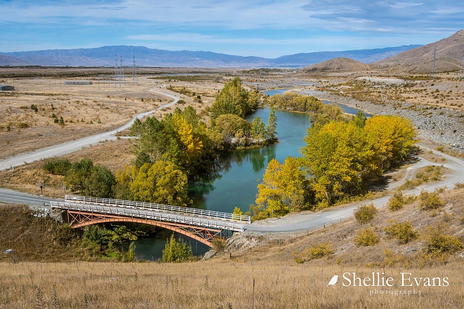
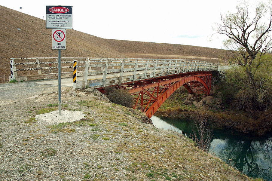
In the 1970s when the upper Waitaki Hydro scheme was constructed and Lake Ruataniwha was formed, the State Highway was realigned bypassing the historic bridge. It now just provides a route to the former river bed and forms an additional "scenic attraction".
List Entry Information
Status
Listed
List Entry Status
Historic Place Category 2
Access
Private/No Public Access
List Number
1965
Date Entered
25th June 2004
Date of Effect
25th June 2004
City/District Council
Mackenzie District
Region
Canterbury Region
Legal description
Crown land (under action) SO 15709, Canterbury Land District. (Currently no RT or gazette notice available)
Location Description
Registration Includes: The bridge on its site.
Status
Listed
List Entry Status
Historic Place Category 2
Access
Private/No Public Access
List Number
1965
Date Entered
25th June 2004
Date of Effect
25th June 2004
City/District Council
Mackenzie District
Region
Canterbury Region
Legal description
Crown land (under action) SO 15709, Canterbury Land District. (Currently no RT or gazette notice available)
Location Description
Registration Includes: The bridge on its site.
Why is this place significant?
Historic Significance
Historical Significance or Value It has historical significance for its role in improving transport links through the Mackenzie Country.
Physical Significance
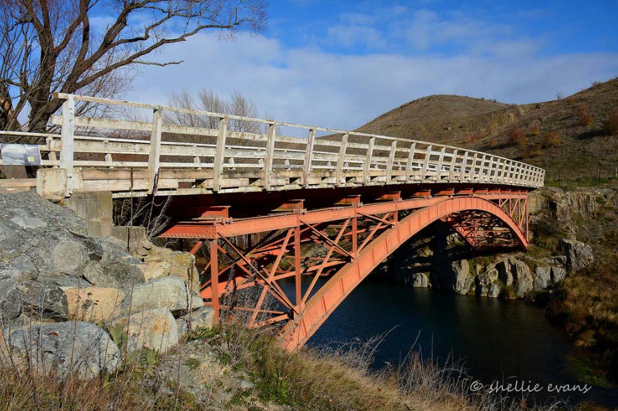
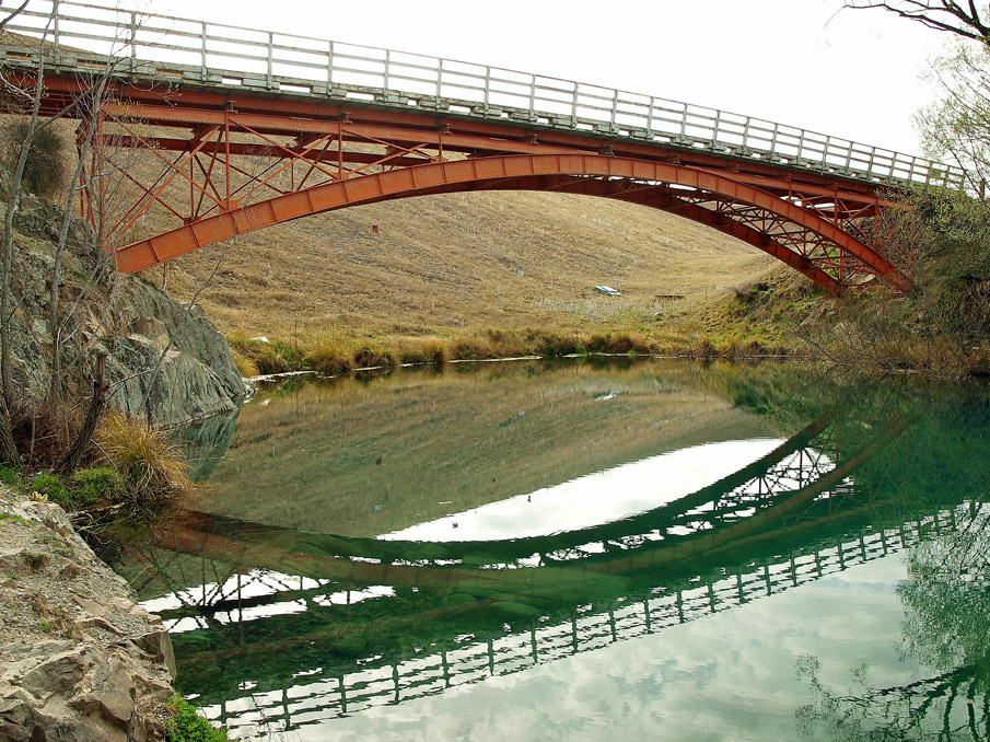
The former Ohau Road Bridge has technological significance as an intact example of a nineteenth century deck arch road bridge.
Why is this place Category 1 / Category 2?
Detail Of Assessed Criteria
(a) it represents the formation of a reliable and comprehensive transport infrastructure throughout New Zealand in the late Victorian period, a factor integral to the country's economic development. (g) It is a technically accomplished and rare example of an intact Victorian single-span deck-arch road bridge. It was regarded to be of sufficient importance to the community to be retained when bypassed by a new highway.
Why is this place significant?
Historic Significance
Historical Significance or Value It has historical significance for its role in improving transport links through the Mackenzie Country.
Physical Significance
The former Ohau Road Bridge has technological significance as an intact example of a nineteenth century deck arch road bridge.
Why is this place Category 1 / Category 2?
Detail Of Assessed Criteria
(a) it represents the formation of a reliable and comprehensive transport infrastructure throughout New Zealand in the late Victorian period, a factor integral to the country's economic development. (g) It is a technically accomplished and rare example of an intact Victorian single-span deck-arch road bridge. It was regarded to be of sufficient importance to the community to be retained when bypassed by a new highway.
Construction Professional
Name
Banks, Charles
Type
Engineer
Biography
No biography is currently available for this construction professional
Construction Details
Start Year
1889
Type
Original Construction
Construction Materials
Steel arch, with a timber balustrade and decking.
Construction Professional
Name
Banks, Charles
Type
Engineer
Biography
No biography is currently available for this construction professional
Construction Details
Start Year
1889
Type
Original Construction
Construction Materials
Steel arch, with a timber balustrade and decking.
A single-span deck-arch bridge, with a clear span of 36.5 metres and an overall length of 41.5 metres. It is single lane width and has heavy river stone abutments.
A single-span deck-arch bridge, with a clear span of 36.5 metres and an overall length of 41.5 metres. It is single lane width and has heavy river stone abutments.
Historical and Associated Iwi / Hapū / Whānau
Completion Date
3rd September 2004
Report Written By
Pam Wilson
Information Sources
Mackenzie District Council
Mackenzie District Council
New Zealand Historic Places Trust (NZHPT)
New Zealand Historic Places Trust
Thornton, 2001
Geoffrey Thornton, Bridging the Gap, Early Bridges in New Zealand 1830-1939, Auckland, 2001
Other Information
The bridge was formerly on State Highway 8, but this highway was realigned after the Ruataniwha Dam was built and the bridge now covers a section of lake water at the termination of Old Iron Bridge Road (See plans in Registration Report). A fully referenced version of this report is available from the NZHPT Southern Region Office. Please note that entry on the New Zealand Heritage List/Rarangi Korero identifies only the heritage values of the property concerned, and should not be construed as advice on the state of the property, or as a comment of its soundness or safety, including in regard to earthquake risk, safety in the event of fire, or insanitary conditions.
Historical and Associated Iwi / Hapū / Whānau
Completion Date
3rd September 2004
Report Written By
Pam Wilson
Information Sources
Mackenzie District Council
Mackenzie District Council
New Zealand Historic Places Trust (NZHPT)
New Zealand Historic Places Trust
Thornton, 2001
Geoffrey Thornton, Bridging the Gap, Early Bridges in New Zealand 1830-1939, Auckland, 2001
Other Information
The bridge was formerly on State Highway 8, but this highway was realigned after the Ruataniwha Dam was built and the bridge now covers a section of lake water at the termination of Old Iron Bridge Road (See plans in Registration Report). A fully referenced version of this report is available from the NZHPT Southern Region Office. Please note that entry on the New Zealand Heritage List/Rarangi Korero identifies only the heritage values of the property concerned, and should not be construed as advice on the state of the property, or as a comment of its soundness or safety, including in regard to earthquake risk, safety in the event of fire, or insanitary conditions.
Current Usages
Uses: Transport
Specific Usage: Bridge/ Viaduct
Former Usages
General Usage: Transport
Specific Usage: Bridge/ Viaduct
Web Links
description: Engineering NZ Heritage
url: https://www.engineeringnz.org/our-work/heritage/heritage-records/ohau-river-bridge/
Current Usages
Uses: Transport
Specific Usage: Bridge/ Viaduct
Former Usages
General Usage: Transport
Specific Usage: Bridge/ Viaduct
Web Links
description: Engineering NZ Heritage
url: https://www.engineeringnz.org/our-work/heritage/heritage-records/ohau-river-bridge/
